Remembering Verplanck Colvin: Stan-Helio to GPS
Verplanck Colvin was a great explorer and surveyor. He was also an inventor who came up with a better way to draw triangles on the Adirondack landscape, and thereby make maps more accurate. He was a master of triangulation, the method used to determine the position of a point by measuring angles to it from known points at either end of a fixed baseline.
GPS works through triangulation. Two satellites draw a straight line between each other, then draw lines to my phone's GPS receiver. Collectively, they update the map they create on my phone. That's fundamentally how GPS works.
Verplanck Colvin’s “Sketch Showing the Progress of the Primary Triangulation.” (Click to enlarge.)
Colvin worked the same way, though his tools were much different. Drawing a straight line between two lighthouses on Lake Champlain near Crown Point and establishing the exact distance between the two, he drew triangles all over the Adirondacks to pinpoint where everything was -- just like GPS, but a lot slower and more arduous. He measured the heights of peaks with barometric measurements, many of which stand up today as being very accurate.
Colvin liked to work in winter when frozen lakes provided additional platforms on which to lay surveyors' chain and make measurements. When they got lost, they'd plant their tents in places they called "Camp Somewhere."
Colvin's surveys led to the establishment of the Adirondack Park, a vast protected area that encompasses six million acres of pristine wilderness. His contributions not only advanced scientific knowledge but also helped to ensure the preservation of natural resources for future generations.
“To map and describe this wonderful region, correcting the errors of early surveyors, and thus furnish a most important contribution to the physical geography of the State, is of course the primary purpose of undertaking the survey,” an 1880 editorial in The Cultivator and Country Gentleman explained. “But Mr. Colvin’s elaborate and interesting reports have been largely instrumental in calling the attention of the public to the attractions of the Adirondack wilderness both for the sportsman and the general tourist, and to the importance of taking any measures that may be necessary to preserve it forever as a mammoth pleasure ground.”
Colvin rooted his advocacy for preservation in the argument that the trees of the forests produced abundant supplies of lumber and that the forest was a crucial source of water to feed rivers, reservoirs, and the Erie and Champlain canals.
He delivered a speech at Lake Pleasant in 1868 that's credited as the first public advocacy for the preservation of the region as a state park. He also poetically expressed the value of wilderness in his conclusion to the second annual report to the State Legislature in 1873:
“The Adirondack wilderness may be considered the wonder and the glory of New York. It is a vast natural park, one immense and silent forest, curiously and beautifully broken by the gleaming waters of a myriad of lakes, between which rugged mountain ranges rise as a sea of granite billows.
"At the north-east, the mountains culminate within an area of some hundreds of square miles; and here savage treeless peaks, towering above the timberline, crowd one another, and, standing gloomily shoulder to shoulder rear their rocky crests amid the frosty clouds.
"The wild beasts may look forth from the ledges on the mountainsides over unbroken woodlands stretching beyond the reach of sight — beyond the blue hazy ridges at the horizon. The voyager by canoe, beholds lakes in which these mountains and wild forests are reflected like inverted reality; now wondrous in their dark grandeur and solemnity; now glorious in resplendent autumn color of pearly beauty……..the quavering note of the loon on the lake; the mournful hoot of the owl at night …….its preservation as a state forest is urgently demanded.”
Colvin's annual reports to the New York Legislature are filled with fascinating maps and drawings. A prolific draftsman, illustrator and writer, he embellished his maps illustrations of his crew's activities.
Colvin completed in 1880 the most thorough survey of the Adirondacks ever accomplished. He continued to work as the State Surveyor for 28 years. His explorations led to the discovery of Lake Tear of the Clouds as the source of the Hudson River and the first accurate elevations for Mt. Marcy and dozens of other regional peaks.
The 'Stan-Helio'
Detail from the historic marker located on Route 28 at the base of Thirteenth Lake Road in North River. (Click to enlarge.)
Among the tools on which Colvin relied were the compass, which enabled his crew to establish bearings; the surveyor's chain, which enabled them to precisely measure distances, and the altimeter, by which they measured elevation.
But none was more important than the massive 300-pound theodolite for which Colvin made a special box and had two men sling on poles to carry up to mountaintops. It had a powerful telescope through which he could precisely measure angles both horizontally and vertically.
When Colvin began his work, the only way to triangulate distances across the Adirondack landscape was to simultaneously set signal fires on two prominent peaks and view them through this theodolite on the peak on which Colvin was standing. That required dispatching three crews to bushwhack up three mountains and synchronize their lighting of fires.
That was a difficult and expensive process, so Colvin came up with an ingenious way to substitute sunlight for fire.
He called it the "Station-Heliograph" or "Stan-Helio." It was a spinning pyramid of shiny tin plates that Colvin devised in 1873 to reflect sunlight at any angle, generating a bright flash that could be seen 30 miles away with the naked eye and further when assisted by a transit.
The Stan-Helio reflected light as “as brilliantly as the facets of a jewel,” Colvin wrote. His crews mounted the device on huge log towers on peaks all over the Adirondacks. In Warren County, these peaks included Gore and Crane.
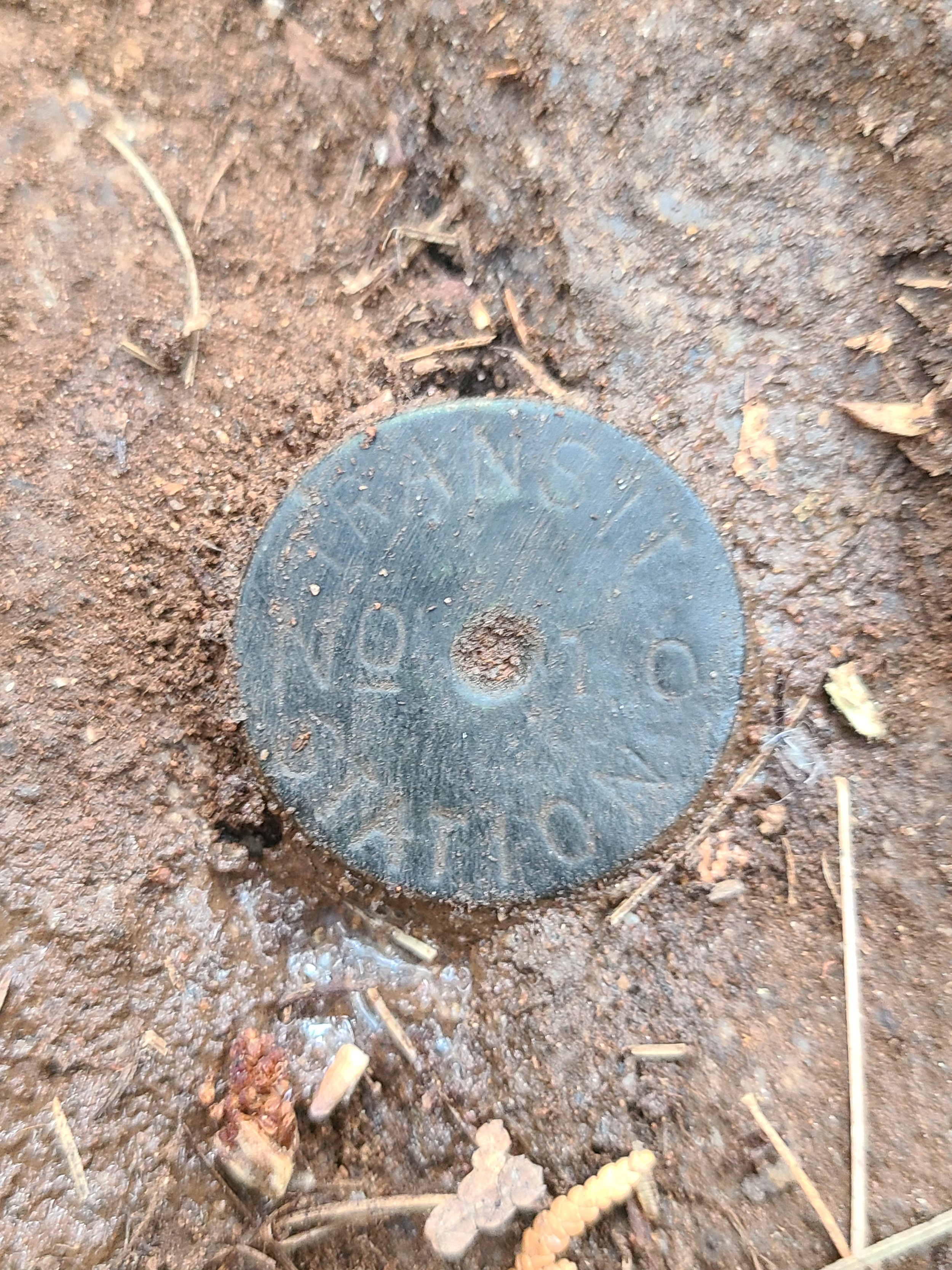
The Search for Colvin Bolts

Greg Schaefer discovering a Colvin bolt.
"If you go up the south side of Gore Mountain, you'll find ring bolts that were used to hold down the tower on which Colvin placed his Stan-Helio," says Greg Schaefer, who has been interested in Colvin for 15 years and for the last three has been searching for survey bolts Colvin's team left all over the southern Adirondacks 120 years ago.
He's joined in this by two friends who also are fans of Colvin and is aided by a surveyor with the Department of Environmental Conservation based in Warrensburg who supplies them with information on these points.
"When we find the actual bolts, we give him the exact GPS points," says Schaefer, whose interest in Adirondack history makes sense given his role as President of the North Creek Depot Museum. "While they have Colvin's maps, they don't know exactly where most of these points actually are so he's glad to have them."
"They're mostly in the ground and the bedrock and they're covered with other rocks so as not to be easily seen or disturbed. I have seen one lodged in a stone fence."
"Many of the earlier surveys had been abandoned or were incomplete. Colvin was out there to set the record straight. So we're following the lines that were important to Colvin at that time. In addition to doing these surveys, he would draw detailed pictures of what he saw from the peaks he was on. His books are full of these sketches.
"Some days we find nothing. Other days we beat ourselves up in the bush and find two or three. But it's always an exciting search. We're putting together the pieces of a puzzle. And bushwhacking is just an entirely different kind of animal than trail-hiking. You're generally just following a compass point to get to where you want to go and you see some of the most incredible rock formations, mosses, and other manifestations of the natural world. It's scenery that most people never see because they have no reason to go back there."
The bolts come in different shapes, Schaefer continues.
"Some of are beautiful cup bolts, while others are just plain, not much more than what looks like a piece of rebar. Once in a while, we come across yellow paint or orange tape that shows that someone with the state has been looking at these lines."
"One of the first bolts I found was in a huge boulder abouf four feet high. And I said to myself, 'This is going to be easy.' I haven't found one similar to that since.
Below is a sampling of bolts they’ve discovered. Each marks a spot where Colvin and his team established a transit station to accurately extend a survey line along a disputed land boundary, an ancient lot line, or to one of the Great Corners he found in his work.